Construction Traveler Information System for I–35 Widening in Central Texas
slide 1: Construction Traveler Information System for I–35 Widening in Central Texas
Jerry Ullman
TTI
May 21, 2013
Bettendorf, Iowa
slide notes:
None
slide 2: Overview: I–35 expansion project
|
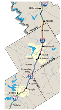 |
slide notes:
Overall, the improvements enhance safety by:
- bringing the interstate to current design standards,
- upgrading exits and entrance ramps,
- converting to one-way frontage roads along the entire length for both access and diversion,
- adding crossing points as well as U-turns at selected crossings,
- adding safety rest areas, and
- reducing congestion through the expansion of capacity.
Mitigate construction impacts, including:
- Access to businesses must be maintained,
- 6 day work week,
- Use of blackout dates, such as Christmas, New Years, and dates with major corridor activity,
- Freeway lane closure limited to evening,
- Sunday from 10:00 pm – 7:00 am
- Monday through Friday from 7:00 pm – 7:00 am
- Contractor assessed lane rental fees, and
- Incentives for completing construction ahead of schedule.
slide 3: Identifying the Problems/Constraints
- Potential for queues during nighttime main lane closures
- Ramp, frontage road, and cross-street closures affecting local access
- Potential for multiple nighttime lane closures along corridor
- Localized delays
- Cumulative delays for through travelers
- Accelerated construction schedule
- Limited coordination of lane closures
- Lane closure locations constantly changing
- ROW cross-section constantly changing
slide notes:
None
slide 4: Specifying User Needs
| Issue | Travelers Affected | Information Needed |
|---|---|---|
| Nighttime freeway lane closures creating traffic queues and speed differentials | All | Real-time warning about downstream queue presence and location |
| Ramp, frontage road, and cross-street closures hindering local access and limiting traffic flow | Local residents, regional travelers | Access to closure information, "pushed" to those who want it |
| Freeway lane closures and incidents creating localized delays | Local residents, regional travelers | Current travel times on I-35 |
| Multiple lane closures along corridor on same night causing significant delays to overall trip | Regional, long-distance travelers | Cumulative predicted delays to be encountered along I-35 |
slide notes:
Finally, TxDOT recognized that the possibility exists for longer-distance travelers on I-35 to encounter multiple delays due to the multiple projects active along I-35. A way to notify motorists about the combined delays of these projects on their trips was needed.
slide 5: System Requirements
- Identification and tracking of planned lane closures
- Current travel time monitoring
- Forecasted travel conditions
- End-of-queue notification
- Information dissemination
- Pre-trip, En-route
- Email, Web, Social Media
- Integration to existing traffic management centers
- Operational and maintenance monitoring
slide notes:
System goals:
- Create traveler information monitoring capability
- Create work zone impacts assessments
- Actively monitor planned closures
- Create traveler information dissemination
slide 6: Identifying Alternatives
✓ Customized solution involving the integration of technologies |
 |
slide notes:
None
slide 7: Concept of Operations
slide notes:
None
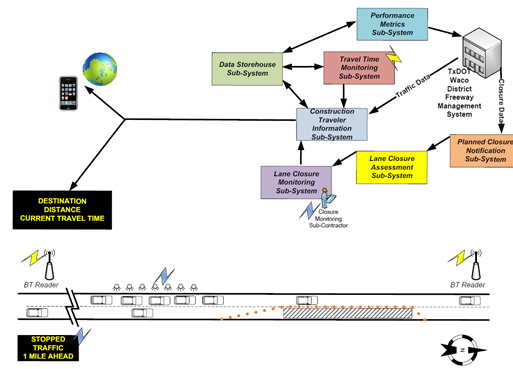
slide 8: Systems Diagram
slide notes:
None
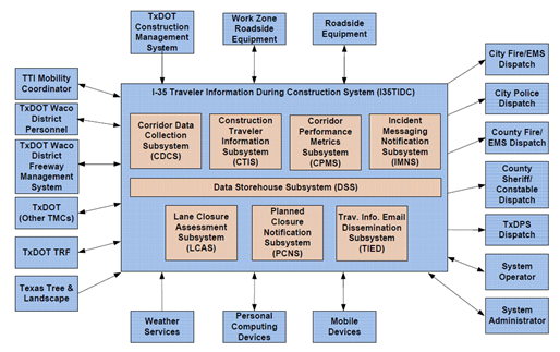
slide 9: System Design Components
- Actively managed lane closure database (PCNS)
- Automated analysis of potential impacts of lane closures (LCAS)
slide notes:
None
slide 10: Components (cont’d)
|
 |
|
 |
slide notes:
None
slide 11: Components (cont'd)
|
 |
slide notes:
None
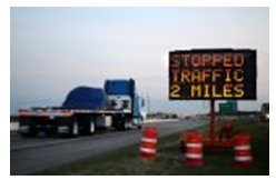
slide 12: Components (cont'd)
|
 |
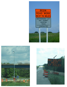
slide notes:
- Multiple vendors of signs
- Some cities have multiple signs to that destination
- ~ 10 mile spacings.
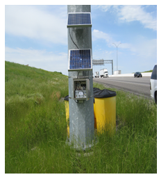
slide 13: Components (cont'd)
|
 |
slide notes:
None
slide 14: Implementation/Procurement
- Field monitoring devices procured and deployed through a contract with TTI
- End-of-queue warning technology procured through project change orders
- Corridor delay forecasting development and calibration continues
- Corridor performance metrics development continues
slide notes:
None
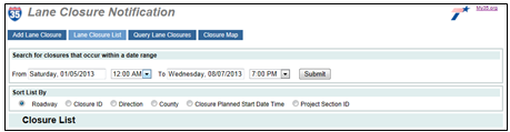
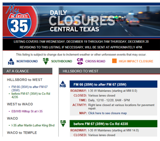
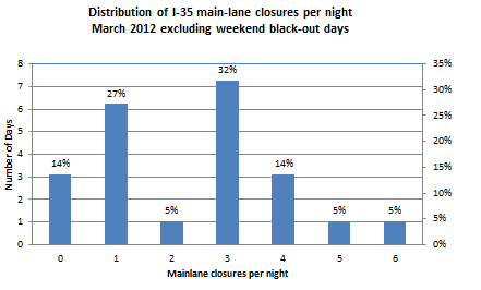
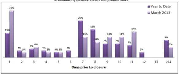
slide 15: Evaluation – Lane closure notifications
|
 |
slide notes:
None
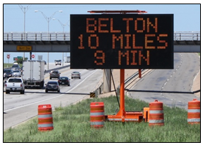
slide 16: Evaluation – Travel Times via PCMS
|
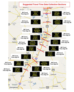 |
slide notes:
None
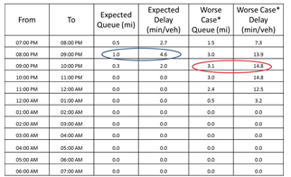
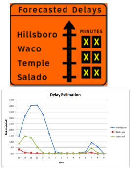
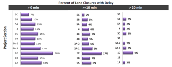
slide 17: Evaluation – Performance Metrics
slide notes:
None
slide 18: Performance Metrics (cont'd)
slide notes:
None
slide 19: Performance Metrics (cont'd)
slide notes:
None
slide 20: Lessons learned
- Balancing lane closure advance notification time versus accuracy is a challenge
- Field infrastructure locations have to move quickly with phasing
- Temporary deployments critical
- Geolocate and track via GPS
- BT spacing can go 5-8 miles in rural settings
- Public does pay attention to real-time information, prefers specifics
slide notes:
None
slide 21: Lessons learned (Cont.)
- Change ordering in technologies to existing projects continues to be a challenge
- Ensuring good data exchange protocols is critical → XML
slide notes:
None
slide 22
 |
Questions? |
slide notes:
None
Return to List of Presentations